Thursday, April 21, 2011

Arches National Park - The Grand Finale

Arches National Park was our last stop before heading east toward home, and it was a spectacular finale.


Our favorite part was getting to climb around IN Double Arch. If you look closely, you can see the tiny dots of people on the right side of the first arch.

David in the opening of the second arch. I tried climbing up too to see what was on the other side, but chickened out. Climbing up wasn't too difficult, it was the return trip that made me nervous.
The famous Delicate Arch. We didn't take the hike right up to it, as the hike to the Upper Viewing location was plenty strenuous for us!
Here we are in front of the Fiery Furnace. Please ignore my dorky chin strap. It was really windy, so it was either wear the strap or chase my hat around.

It was a fabulous vacation and I hated to see it end. After we left Arches, we made tracks east to Denver and then to home. Time to start planning our next trip! Where to, David?

Wednesday, April 20, 2011

Highway 12

Highway 12 Scenic Byway begins outside Zion National Park and continues to Torrey, UT (near the entrance to Capitol Reef NP) and was about as interesting as visiting the parks themselves. Can you spot the road in this first picture?I wanted a picture of this swiss cheese-like rock, but realized that it wouldn't look as big without some perspective. So I shimmied (no really, I did!) into one of the holes.

In the dry dry air, metal and wood things seem to last much longer. We spied this old truck from the highway and had to get a picture.

For more information on this scenic highway, click here: http://www.utah.com/byways/highway_12.htm. If you are out that way and don't take this highway, you are missing out on beautiful scenery! And the excitement of a road that rides the ridge of a mountain with steep drop offs on both sides. You don't want to miss that, do you? ;)

Tuesday, April 19, 2011

Bryce Canyon and Capitol Reef

I am one lucky traveler. David does an excellent job of planning our adventures, and I pack my clothes and get in the car. I'm spoiled, I know. I didn't do much (any) research on the places we were going. I thought, Arizona, Utah, Spring. And packed accordingly. Had I looked up Bryce Canyon on the internet, I would have learned that the elevation ranges from 8,000 to almost 10,000 feet and that the average high in April is 56. I would have learned that, but I didn't.So I was ill prepared for the 34 degree day that blessed us while visiting Bryce. I think that's why it wasn't one of my favorites. It's beautiful and breathtaking, but I was mostly just cold.
We didn't let the temps prevent us from taking a couple walks to lookouts where you can see almost forever.
After we got home, I looked at the weather forecast for Bryce to find that they were expecting 2-4 FEET of snow last Sunday. I am suddenly glad for the 34 degree DRY day!
We also visited Capital Reef National Park while passing through. It was neat because you can drive back into the canyons on gravel and rock roads. We also saw more wildlife there - mule deer, mountain bluebirds, and a marmot.
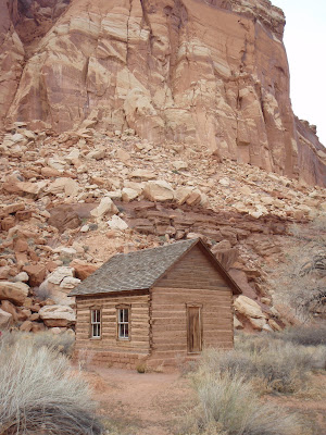
The remains of a community called Fruita are part of the park. This is the still-furnished school house.

Monday, April 18, 2011

Zion National Park

Zion was one of our favorite national parks that we visited on this trip.There were lots of people, but not too many and the weather was perfect.
We rode the shuttle to the end, took a 2-mile walk back through the canyon to where the trail called the "Narrows" begins. Unfortunately the trail was closed due to high water. If not, I'm just sure we would have hiked it! What are you laughing at? ;)
Our hike, the shuttle ride, and the road provided us with beautiful sights and blue blue skies.
This is the view from one of the scenic stops looking down at another scenic stop. It's a LONG way down there!
The waterfall was so pretty. We must have a dozen pictures of it from all different angles. I would definitely go back there some day.

Sunday, April 17, 2011

Burma Road

As David, and Charles Kuralt, noted it's possible to stay on big highways and not see much of anything. Whenever we pass an interesting looking dirt road, David gets a little gleam in his eye. Usually we just travel on though. We have some place to be, not enough time to explore. With our change in plans due to the road to the North Rim being closed, we had a little unexpected time. Enough time to check out this narrow steep road call Burma Road.So off we went. We met one car full of young men going the other way, but that was the only other sign of life for quite a while.
The truck cooperatively posed for a few pictures.
We saw a sign noting that this was a burned area and to watch for fallen trees. We soon came upon a national forest employee who was working on clearing some trees from the road. He was very friendly, and answered all of our questions. He told us that the fire had been in 2006, and that every time the wind blows, a new set of burned trees fall. Sure enough, just a little way up the road a large pine had fallen and was blocking the road. Not deterred, David winched it out of the way while I walked around in the woods thinking how it smell like a campfire.
Here's a shot of some of the burned area. It was very strange to look across and see a whole hill's worth of trees blackened.
The fallen tree didn't slow us down much and we are almost at the end of the road where it would drop us back at a highway when we encountered snow. David worked and got us through a large patch of wet, heavy snow, but as we reached the top of the road, we could see that we couldn't make it to the highway that way. We turned around and headed back down. Even though we were retracing our steps, everything sure looked different from the other direction!

Saturday, April 16, 2011

Glen Canyon

Since the North Rim was a no-go, we visited the Glen Canyon National Recreation Area at our waitress's suggestion. The scenery was gorgeous - inspiring one of us to take on the "I'm on top of the world" pose. But we won't say who.
The Colorado rive winds through this area before it heads toward the Grand Canyon, making it, well, grand.
You can't tell from this picture how hard it was to get. It involved some climbing across damp rocks after setting the timer. I'm laughing in it because David arrived just as the flash went off.
The remains of a little village of Lee's Ferry are still here, including this old window. We took a little hike to see these and another to see the orchard and old lodge.

Friday, April 15, 2011

Navajo Bridge, Arizona

Our waitress from the Lee's Ferry Lodge suggested a walk across the Navajo Bridge, so we did just that. It was less frightening than I expected, as it was pretty wide.Stepping to the edge was a little more of an adventure, but the view was so incredible that it had to be done.
David walked back the way we came, but I could not resist going all the way to the other end and taking a few silly shots while I was there.
I just liked the light and shadows for this last shot. The desert has to have some of the most interesting sunlight I've seen.
You can read more about the Navajo bridge here: http://www.nps.gov/glca/historyculture/navajobridge.htm.

Thursday, April 14, 2011

Lee's Ferry Lodge

The hotels we stayed at were all nice, clean, lovely places. But one really deserves it's own post, and it is the Lee's Ferry Lodge. To get there, you drive through reservation land to approximately the middle of absolutely no where. Then you drive a little further, admiring the way the setting sun turns the canyon walls a fiery shade of red. After the Navajo bridge, turn left. Pass the first lodge and drive a few more miles to the second one (and only other on this stretch of road). You'll first be greeted by a friendly Great Pyrenees mix, who is doing a great job of guarding the place as she turns over for you to scratch her tummy. To check in, you'll go into the lodge restaurant where they will pull out a large paper ledger to find your reservation. With pencil in hand, the host will put a check mark through your name. Not a computer in sight.
Next, they'll hand you a key - an actual key! - to your room. The dog will follow you there and wait outside the door while you unpack. Head back to the dark, woodsy lodge for dinner before crashing in the pleasantly decorated bed. The room looks more like someone's guest room than a hotel room.
After you wake up, head back to the lodge for a delicious breakfast.
Ask your waitress for ideas of what you should do that day, as she'll know. She'll also be the one to snort "Good luck with that!" when you tell her that you're planning to go to the North Rim of the Grand Canyon. See, she knows something you don't and that is that the road to the North Rim won't be open until mid-May due to snow.
But she'll give you ideas for other things to do, and those things will be fun too.
Marvel at your good fortune to stay and sleep and eat at some place so far from anywhere. Discuss with your travel partner whether you could live somewhere so remote, and decide that it was wonderful to visit, but no probably couldn't live there.

Wednesday, April 13, 2011

Red Rock Country

Last time we were in Sedona, it was July and just incredibly hot. I enjoyed it so much more this time! David's cousin, Paula, and her husband, Jess live there and were so kind to take us to lunch and on a tour of the town.
Having lived there for 14 years, they are a wealth of information that we wouldn't have gotten otherwise. And they're lots of fun!When David learned that they don't have (or need) a lawnmower, I thought I might have to fly back to Springfield without him to pack up the animals and drive back. I really wasn't sure he was going to leave! I can't say that I blame him. It really is a beautiful place.As we were leaving Sedona, this is what the GPS showed for the upcoming road.
Lots to see, even on the road "more" traveled!


Tuesday, April 12, 2011

Meet Me at the Mission At Midnight

In need of a break from all things vehicular, David took me to Tumacacori, a misson begun in the mid-1800's. It's about 30 miles north of the Mexican border. Since I can't seem to get into the National Park website (government shutdown?), and we only borrowed the little booklet, I can't tell you much about this place, other than it was very interesting. And that a wedding was being set up there as we were getting ready to leave. A few things that I remember: The church was only part of a mission and was often built last as was this case.
Here we are, being a little silly (blame the heat) in the food storage area of the mission.
This was also the food storage area. I was fascinated by the light coming in through all the windows, doors, and open roofs.
I don't know this guy. ;)
Can you spot David in the picture above? That's his Gracie impression.
The cemetery. Two priests are also buried in the floor of the alter area of the church.
Before the NPS took over the mission and began work to improve it, countless people passing through used it for shelter. The picture above is taken from the robe room where priests would prepare for the church service. There is graffiti on the walls dating back to the 1800's, and the ceiling is black from the many fires built in that room for warmth by people traveling.

Even when the church was in use, there were no pews or chairs. The congregation would spend the entire service alternating between kneeling on the rock floor or standing. Hope those sermons weren't long!


Post title credit: The Refreshments, Banditos